Vancouver, Canada – January 30, 2023 – Tier One Silver Inc. (TSXV:TSLV, OTCQB:TSLVF) (“Tier One” or the “Company”) is pleased to announce that recent geophysical survey results, combined with existing exploration data sets, have led to the identification of two porphyry copper targets underlying the silver-gold epithermal mineralization defined on surface at its Curibaya project in southern Peru. Tier One Silver completed a 42.7-line kilometre (km) Controlled-Source-Audio-Frequency Magnetotelluric (CSAMT) geophysical survey over the central portion of the Curibaya project in late 2022 (Figure 1). These new data sets were integrated into the exploration model, building on previous geophysical, geochemical and geological data sets, to generate targets for the Company’s next drill program at the project. The drilling, which is anticipated to begin in Q2, will comprise of approximately 5,000 metres (m) to follow-up on the high-grade silver-gold epithermal mineralization defined at surface and target the two main conductive features that may relate to a porphyry system.
Highlights:
- CSAMT identifies two sub-vertical, low resistivity anomalies (400 m x 400 m and 600 m x 500 m) that are interpreted to be associated with a large-scale hydrothermal alteration system
- Anomalies correlate with areas of multiphase alteration systems, including:
- Advanced argillic alteration
- Skarn and hornfels
- Sericite – phengite – muscovite
- Anomalies correlate with elevated bismuth, tellurium, selenium and copper values in rock samples
- Absolute dating of alteration mineral in anomalies yielded a Paleocene age of 55Ma, which is a similar age to the regional porphyry copper giant deposits, Toquepala (57Ma), Cuajone (52Ma) and Quellaveco (55 Ma)
A Message from Christian Rios, SVP, Exploration:
“We believe the targets we’ve identified could be associated with a porphyry copper system at depth, particularly considering the absolute dating results, which indicate the mineralization to be from the Paleocene era. This provides further evidence that we are in the correct regional environment as the similar Paleocene-aged giant porphyry copper deposits nearby. We look forward to testing these strong targets in our next drill campaign.”
CSAMT Results:
A CSAMT geophysical survey was completed in October 2022 to augment previously completed geophysical, geochemical and geological surveys. CSAMT is used as an exploration tool to identify deeply rooted resistive and conductive features that may correlate to feeder and breccia structures, and/or zones of silicification and clay alteration, possibly related to porphyry copper targets (Figure 2). An inversion of the Curibaya CSAMT data outlines two main conductive features that are 400 m by 400 m and 600 m by 500 m, respectively, and show significant depth extent over 700 m (Figure 3). Pseudo sections for lines L5800 and L6200 clearly illustrate sub-vertical conductive features (Figure 4).
Both the high conductivity and low resistivity features are sub-vertical and located under important alteration features such as an advanced argillic lithocap, a skarn and hornfels area and a white mica alteration area. Additionally, these conductive anomalies are geochemically anomalous in bismuth, tellurium, selenium and copper. The hydrothermal alteration present in the upper part of the system and the geophysical features are consistent with buried porphyry systems.
Strategy for H1 2023:
The synthesis and interpretation of these targets is ongoing and includes re-logging core and continued integration with other geophysical and geochemical datasets. The Company expects to have defined drill targets in the coming weeks. Upon completion of target definition, a drill program will be finalized to test for both the possible porphyry source (drilling to a depth of 500m – 800m) and the epithermal silver – gold structures (between 150m – 250m) on the property. The exploration field program is expected to start in Q2 2023.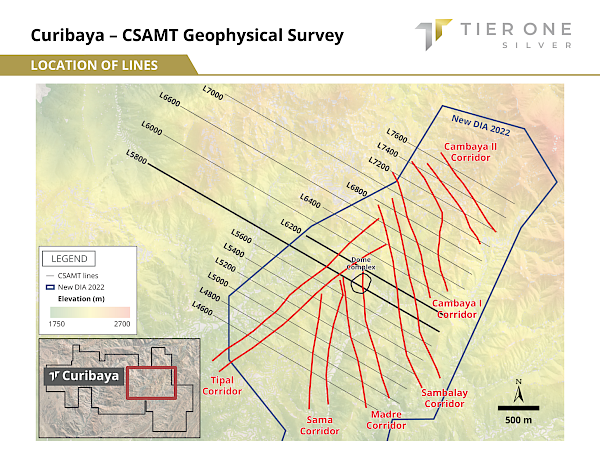 Figure 1: Illustrates a general location map of the CSAMT lines for the survey that was conducted in October 2022.
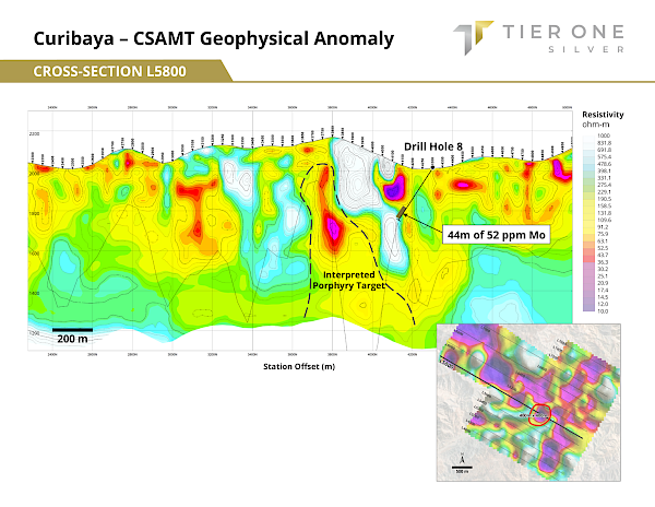 Figure 2: Illustrates line L5800 and the zones of lower resistivity and higher conductivity, which may indicate zones of intense hydrothermal alteration that could be associated with a porphyry copper system. In addition, drill hole 8 is illustrated, which encountered 44 m of 52 ppm of molybdenum at a depth of approximately 270 m, which is another indication of a potential porphyry copper system.
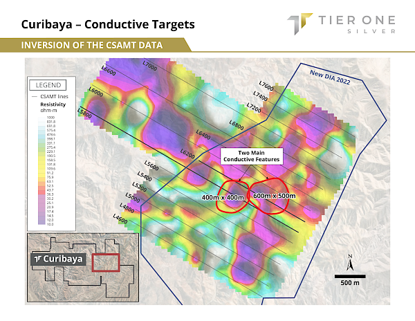 Figure 3: An inversion of the CSAMT data outlines two main conductive features. Tier One Silver plans to test these porphyry copper targets in its next drill program. The CSAMT survey tested to a depth of 500 m.
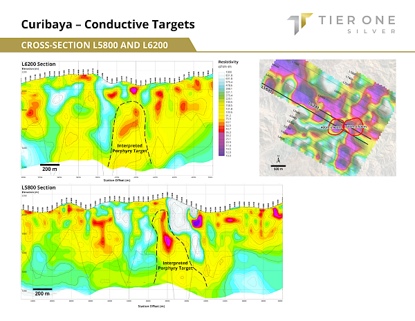 Figure 4: Illustrates pseudo-sections for lines L5800 and L6200 and the sub-vertical conductive features.
The Company is also announcing that Michael Henrichsen is retiring as Chief Geologist of Tier One Silver to focus his efforts as Chief Geological Officer of Torq Resources. Tier One has been transitioning toward this restructuring since the appointment of Christian Rios as SVP of Exploration, who will be leading exploration operations at the Company going forward. Mr. Henrichsen will still be available to Tier One as a consultant, as needed.
Christian Rios (SVP of Exploration), P.Geo, is the Qualified Person who has reviewed and assumes responsibility for the technical contents of this press release.
ON BEHALF OF THE BOARD OF DIRECTORS OF TIER ONE SILVER INC.
Peter Dembicki
President, CEO and Director
For further information on Tier One Silver Inc., please contact Natasha Frakes, VP, Communications, at (778) 729-0600 or info@tieronesilver.com
About Tier One
Tier One Silver is an exploration company focused on creating value for shareholders and stakeholders through the discovery of world-class silver, gold and base metal deposits in Peru. The Company’s management and technical teams have a strong track record in raising capital, discovery and monetization of exploration success. The Company’s exploration assets in Peru include: Hurricane, Coastal Batholith, Corisur and the flagship project, Curibaya. For more information, visit www.tieronesilver.com.
CSAMT Parameters
The CSAMT survey was carried out by Quantec Geoscience Perú S.A.C., a company based in Vancouver with divisions operating in South America, including Peru. Data points were collected on grid lines-oriented NW-SE using 50 m station spacings, covering an area of approximately 4.5 km x 3.5 km. Overall, data quality is considered well above average and no stations were affected by external factors.
Results were compiled into sections, grid maps and a 3D Voxel model. Occam or Marquardt 1D Inversions are first used to invert the data to produce a smooth-layer 1-D resistivity/depth curve for each station. To avoid the effects of the near-field, some frequencies were removed.
Readings are statistically averaged based upon adjacent points to produce an associated value for each cell. Quantec Geoscience Perú S.A.C. provides high confidence in readings to a depth of at least 700 m.
Forward Looking Information and General Cautionary Language
This news release contains forward-looking statements and forward-looking information within the meaning of Canadian securities legislation (collectively, “forward-looking statements”) that relate to the Company’s current expectations and views of future events which are not historical facts and may be forward-looking statements and may involve estimates, assumptions and uncertainties which could cause actual results or outcomes to differ materially from those expressed in such forward-looking statements. No assurance can be given that these expectations will prove to be correct and such forward-looking statements included in this news release should not be heavily relied upon. These statements speak only as of the date of this news release. In particular, and without limitation, this news release contains forward-looking statements with respect to exploration plans.
Readers should refer to the risks discussed in the Company’s Annual Information Form and Management’s Discussion & Analysis for the year ended December 31, 2021, and subsequent continuous disclosure filings with the Canadian Securities Administrators available at www.sedar.com.
Neither the TSX Venture Exchange nor its Regulation Services Provider (as that term is defined in the policies of the TSX Venture Exchange) accepts responsibility for the adequacy or accuracy of this release.
SOURCE: Tier One Silver Inc.
Featured Image MegaPixl @Andorapro
Information About This Article and Cautionary
This Article is a cash-paid communication of Tier One Silver Inc. which has retained media company Native Ads Inc to collaborate on its content and arrange for the Article’s dissemination through various media platforms via Market Jar Media Inc. Tier One is solely responsible for the factual content of the article as regards Tier One and any other facts or opinions expressed are those of Native Ads and not those of Market Jar Media Inc., or its management or shareholders. Market Jar Media Inc.’s terms of use of the Article can be found at: terms of use and disclaimer. Market Jar Media Inc. has or expects to receive from Tier One Silver Inc.’s Digital Marketing Agency of Record (Native Ads Inc.) one hundred and sixty five thousand, seven hundred and thirty two Canadian dollars for up to 180 days (125 business days). Neither the Native Ads or Market Jar Media Inc or their respective management or shareholders hold any securities of Tier One. The Article is not intended to be investment advice nor a solicitation for purchase of securities but is provided for general interest purposes.
The Article does not constitute investment advice. All investments carry risk and each reader is encouraged to consult with his or her individual financial professional.
Mining is a high risk business and very few junior mineral exploration companies are ultimately successful in finding a mine. For information about the risks facing Tier One and the limitations inherent in any forward looking statements in the Article see Tier One Silver Inc.’s regulatory filings at www.SEDAR.com.
Christian Rios (SVP of Exploration), P.Geo, is the Qualified Person who has reviewed and assumes responsibility for the technical contents of this report.
Rock grab samples are selective samples by nature and as such are not necessarily representative of mineralization hosted across the property. The rock grab samples represent vein samples that range in width from 5 centimeter to 1 meter and are situated in north-south structural corridors. These veins are an indication of metal budget; however, are not the target themselves. The Company believes that concentrations of precious metal veins can occur along the defined structural corridors and that geologic targets include high-grade veins in excess of 1 meter width, vein stockwork zones, and hydrothermal breccias that could be found through exploratory drilling.


